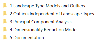
Data package contents
The data package download is independent of any actions you take in the User interface. You can skip all model review steps in the User interface and go straight to download all of your data. The data package contains the following:
1 Landscape type maps and outliers
This folder contains the outputs by landscape type for all landscape models.
It contains 12 folders. The number in front of the folder pertains to the number of landscape types in the respective model. Use the outputs from the folder that contains the amount of landscape types you believe best suits your survey area. If you are unsure, it is easiest to review this data in the online User interface.
Each folder contains:
-
Geochemistry by landscape type
-
Boxplots for each element by landscape type (.png)
-
Outliers by landscape type for each element (.gpkg, .shp)
-
Landscape maps
-
Landscape map (.png, .tif)
-
Clusterbox with pixels in 3D coloured by landscape type (.html)
-
Geochemistry as CLR values and all outliers (.csv)
2 Outliers independent of landscape types
This folder contains outlier calculations of the uploaded geochemistry without consideration of landscape types. These outliers are calculated from the whole population and are useful for comparison to outliers calculated from the sub-populations (outliers calculated for each landscape type).
The folder contains:
- Outliers by landscape type for each element (.gpkg, .shp)
3 Principal Component Analysis
Your data package includes Principal Component Analysis of all elements for all samples you uploaded with the aim to provide a first-pass multi-element geochemistry interpretation tool to identify potential areas of interest.
The folder contains:
-
Spider diagram and spatial plots (.png)
-
Principal Components for each sample (.shp, .csv)
-
Eigenvalues (.csv)
4 Dimensionality reduction model
This is the dimensionality reduction (UMAP) model of your area that is the basis for the landscape type maps. We called it Similarity Model in the User Interface.
Background
Uniform Manifold Approximation and Projection (UMAP) is a dimensionality reduction algorithm used to transform the spatial input data for each project area to a three-dimensional representation of data.
This folder contains:
-
2D UMAP of the model area coloured in red-green-blue (.png, .tif)
-
3D UMAP of pixels in the model area in a clusterbox (.html)
5 Documentation
The documentation folder contains useful information that will help you interpret and work with the model outputs. The folder contains:
-
A readme.txt file that includes model inputs and parameters and source and version controls
-
The online User Guide as a PDF
